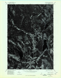
1975 Map of Skowhegan SE
USGS Topo · Published 1980About this map
Carrabassett Stream winds through a landscape of dense woodland and scattered agricultural clearings in this mid-1970s orthophotoquad of Somerset County. The imagery reveals the rural character of the region, where crossroads like Mitchell Corner and Browns Corner anchor a network of local roads and farmsteads. These small settlements reflect a traditional New England land-use pattern, with habitation clustered around specific intersections amidst the topographical rise of Chase Hill and Whitten Hill. Unlike a standard line-drawn map, this aerial perspective allows for a direct study of 1970s vegetation patterns and the exact footprint of residential and farm structures, providing a clear record of the area's development before modern suburban shifts or forest regrowth altered the visual landscape.
Find a feature on this map
5 named features on this map. Tap any name to fly to it.
Don’t see what you’re looking for? This feature index may not catch every label — zoom into the map to look around manually.
Map Details
Editions of this 1975 Skowhegan SE Map
This is the sole edition of this map. No revisions or reprints were ever made.
Other maps of this area

1892 · Waterville
USGS Topo · 1:62,500

1913 · Skowhegan
USGS Topo · 1:62,500

1926 · Burnham
USGS Topo · 1:62,500

1930 · Pittsfield
USGS Topo · 1:48,000

1932 · Pittsfield
USGS Topo · 1:62,500

1933 · Pittsfield
USGS Topo · 1:62,500

1943 · Waterville
USGS Topo · 1:62,500

1948 · Bangor
USGS Topo · 1:250,000

1955 · Pittsfield
USGS Topo · 1:62,500

1955 · Skowhegan
USGS Topo · 1:62,500