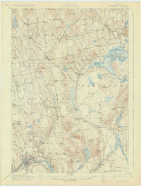
1913 Map of Skowhegan
USGS Topo · Published 1927About this map
The Kennebec River bends sharply through Skowhegan, where the Maine Central railroad and a dense concentration of local industry define the riverfront at the Great Eddy. This 1912 survey illustrates a landscape of established townships like Athens, Harmony, and Cornville, each dotted with a remarkably high density of rural schoolhouses and small mills. The settlement patterns reveal the agrarian and industrial backbone of the county, from Waltons Mill to the uniquely named Slab City. Moving east, the terrain transitions into the water-rich geography surrounding Moose Pond and Sibley Pond. Grounded in the work of surveyors like Hersey Munroe and Olinus Smith, the map records specific local landmarks such as Union Church and South Cemetery, providing a precise look at the road networks and family-named hills like Whittemore Hill and Jewell Hill that shaped central Maine life.
Find a feature on this map
125 named features on this map. Tap any name to fly to it.
Don’t see what you’re looking for? This feature index may not catch every label — zoom into the map to look around manually.
Map Details
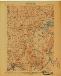
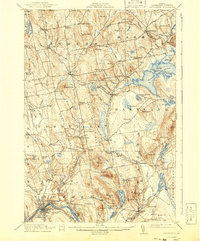
Editions of this 1913 Skowhegan Map
4 editions found
Other maps of this area

1892 · Waterville
USGS Topo · 1:62,500

1894 · Norridgewock
USGS Topo · 1:62,500

1898 · Norridgewock
USGS Topo · 1:62,500

1903 · Bingham
USGS Topo · 1:62,500

1904 · Anson
USGS Topo · 1:62,500

1905 · Bingham
USGS Topo · 1:62,500

1913 · Skowhegan
USGS Topo · 1:62,500

1926 · Burnham
USGS Topo · 1:62,500

1930 · Pittsfield
USGS Topo · 1:48,000

1932 · Pittsfield
USGS Topo · 1:62,500