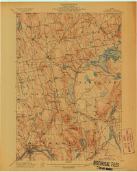
1913 Map of Skowhegan
USGS Topo · Published 1913About this map
The Kennebec River anchors the southwest corner of this Somerset County landscape, where the bustling community of Skowhegan is defined by the Great Eddy and the tracks of the Maine Central RR. This 1912 survey illustrates a region shaped by its waterways and small-scale industries, featuring Waltons Mill and Malbons Mills alongside the winding Wesserunsett Stream. The map reveals a dense network of district schools, including the Slab City School and Kinsman School, which served the scattered farming settlements of Cornville and Athens.
Find a feature on this map
125 named features on this map. Tap any name to fly to it.
Don’t see what you’re looking for? This feature index may not catch every label — zoom into the map to look around manually.
Map Details
Editions of this 1913 Skowhegan Map
4 editions found
Other maps of this area

1892 · Waterville
USGS Topo · 1:62,500

1894 · Norridgewock
USGS Topo · 1:62,500

1898 · Norridgewock
USGS Topo · 1:62,500

1903 · Bingham
USGS Topo · 1:62,500

1904 · Anson
USGS Topo · 1:62,500

1905 · Bingham
USGS Topo · 1:62,500

1913 · Skowhegan
USGS Topo · 1:62,500

1926 · Burnham
USGS Topo · 1:62,500

1930 · Pittsfield
USGS Topo · 1:48,000

1932 · Pittsfield
USGS Topo · 1:62,500