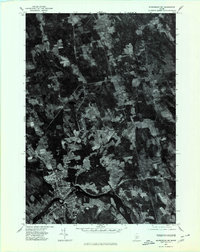
1975 Map of Skowhegan SW
USGS Topo · Published 1980About this map
The Kennebec River carves through the southern landscape of this 1975 orthophotoquad, defining the industrial and residential core of Skowhegan. This unique aerial perspective shows the town's dense layout and riverside development just as it appeared in the mid-1970s. North of the main settlement, the land transitions into a patchwork of woodlots and agricultural clearings along the winding Wesserunsett Stream. Small rural nodes like Malbons Mills and Lower Mill reflect the area's history of water-powered industry, while Wesserunsett Lake sits at the western edge of the sheet. Unlike standard topographic maps, this imagery provides a direct view of the exact vegetation patterns and field boundaries of the era, offering a precise visual record of Somerset County's land use before later twentieth-century changes.
Find a feature on this map
6 named features on this map. Tap any name to fly to it.
Don’t see what you’re looking for? This feature index may not catch every label — zoom into the map to look around manually.
Map Details
Editions of this 1975 Skowhegan SW Map
This is the sole edition of this map. No revisions or reprints were ever made.
Other maps of this area

1892 · Waterville
USGS Topo · 1:62,500

1894 · Norridgewock
USGS Topo · 1:62,500

1898 · Norridgewock
USGS Topo · 1:62,500

1904 · Anson
USGS Topo · 1:62,500

1913 · Skowhegan
USGS Topo · 1:62,500

1943 · Norridgewock
USGS Topo · 1:62,500

1943 · Waterville
USGS Topo · 1:62,500

1948 · Bangor
USGS Topo · 1:250,000

1955 · Anson
USGS Topo · 1:62,500

1955 · Skowhegan
USGS Topo · 1:62,500