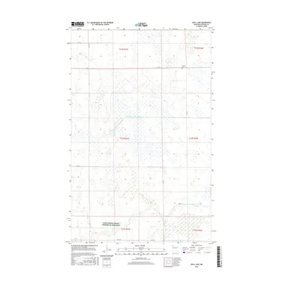
2016 Map of Skull Lake
USGS Topo · Published 2016About this map
Hydrological engineering and conservation management define this northern Kittson County landscape. The area is dominated by an extensive network of drainage infrastructure, most notably the State Ditch Number Eightyfour and State Ditch Number Eightyfive, which facilitate agricultural use of the flat terrain. Near the southern edge, the N Br Two Rivers meanders through the township lines, providing a natural contrast to the straight-line drainage canals. Human settlement is sparse in this portion of the Red River Valley, with the McKinley Cem serving as a primary local landmark and genealogical touchstone. Large tracts of land, including the Farm Service Agency Interest of Minnesota, reflect contemporary land use and preservation efforts in this border region. Local transportation is anchored by a grid of county roads, such as Co Rd 51 and Co Rd 52, which provide access to these remote farmsteads.
Find a feature on this map
19 named features on this map. Tap any name to fly to it.
Don’t see what you’re looking for? This feature index may not catch every label — zoom into the map to look around manually.
Map Details
Editions of this 2016 Skull Lake Map
This is the sole edition of this map. No revisions or reprints were ever made.
Other maps of this area

1918 · Hemmington
USGS Topo · 1:62,500

1941 · Hallock
USGS Topo · 1:62,500

1952 · Thief River Falls
USGS Topo · 1:250,000

1956 · Thief River Falls
USGS Topo · 1:250,000

1957 · Thief River Falls
USGS Topo · 1:250,000

1966 · Skull Lake
USGS Topo · 1:24,000

1966 · Skull Lake NE
USGS Topo · 1:24,000

1966 · Skull Lake SE
USGS Topo · 1:24,000
1966 · Skull Lake SW
USGS Topo · 1:24,000

1967 · Thief River Falls
USGS Topo · 1:250,000