
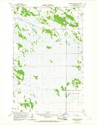
1966 Map of Skull Lake NE
USGS Topo · Published 1967About this map
The Canada United States international boundary anchors this mid-1960s survey, where the Manitoba Minnesota line meets the rural townships of McKinley and Caribou. The landscape is defined by an extensive network of water management, illustrated by numerous engineered channels such as County Judicial Ditch No 32 and State Ditch No 84. These features reveal the significant human effort required to drain and manage this low-lying borderland for agricultural or resource use. Settlement patterns are sparse, following the township divisions of Cannon and the neighboring Provencher District across the border. A lone Gaging Station in the northeast corner and various county ditches like County Ditch No 11 point to a region deeply tied to hydrological monitoring and land reclamation in the far reaches of Kittson County.
Find a feature on this map
14 named features on this map. Tap any name to fly to it.
Don’t see what you’re looking for? This feature index may not catch every label — zoom into the map to look around manually.
Map Details
Editions of this 1966 Skull Lake NE Map
This is the sole edition of this map. No revisions or reprints were ever made.
Other maps of this area

1918 · Hemmington
USGS Topo · 1:62,500

1930 · Juneberry
USGS Topo · 1:31,680

1932 · Juneberry
USGS Topo · 1:62,500

1952 · Thief River Falls
USGS Topo · 1:250,000

1956 · Thief River Falls
USGS Topo · 1:250,000

1957 · Thief River Falls
USGS Topo · 1:250,000

1966 · Skull Lake
USGS Topo · 1:24,000

1966 · Caribou
USGS Topo · 1:24,000

1966 · Skull Lake SE
USGS Topo · 1:24,000
1966 · Juneberry Ridge
USGS Topo · 1:24,000