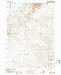
1989 Map of Skunk Lake NE
USGS Topo · Published 1989About this map
The Niobrara River winds through the northwestern corner of this landscape, its path defined by the steep bluffs and complex drainage systems of northern Sheridan County. This late 1980s provisional survey illustrates a remote ranching region where large landholdings predominate, notably the Sandoz Ranch located in the southeastern quadrant. The topography is dominated by the sandy hills and seasonal wetlands characteristic of the Sandhills transition, with Box Butte Creek feeding into the river system. The settlement at Box Butte serves as a primary geographic marker in a territory otherwise defined by section lines and natural watercourses. For those researching Great Plains land use, the map provides a clear record of fence lines, trails, and ranching infrastructure before modern digital mapping became standard.
Find a feature on this map
5 named features on this map. Tap any name to fly to it.
Don’t see what you’re looking for? This feature index may not catch every label — zoom into the map to look around manually.
Map Details
Editions of this 1989 Skunk Lake NE Map
This is the sole edition of this map. No revisions or reprints were ever made.
Other maps of this area

1948 · Twin Lakes
USGS Topo · 1:62,500

1950 · Twin Lakes
USGS Topo · 1:62,500

1950 · Skunk Lake
USGS Topo · 1:62,500

1955 · Alliance
USGS Topo · 1:250,000

1957 · Alliance
USGS Topo · 1:250,000

1958 · Alliance
USGS Topo · 1:250,000

1960 · Hay Springs SW
USGS Topo · 1:24,000

1960 · Hay Springs SE
USGS Topo · 1:24,000

1966 · Rushville SW
USGS Topo · 1:24,000
1985 · Gordon
USGS Topo · 1:100,000