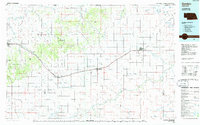
1985 Map of Gordon
USGS Topo · Published 1985About this map
The Chicago and North Western corridor defines the mid-1980s landscape of Sheridan County, linking the primary agricultural hubs of Gordon, Rushville, and Hay Springs. This transition zone between the Nebraska Sandhills and the Pine Ridge is anchored by significant public lands, including the eastern reaches of the Nebraska National Forest and the Metcalf State Wildlife Management Area. The map reveals a complex hydraulic network where the White River flows northwest toward the South Dakota border, while the Niobrara River carves its way through the southern plains, supported by numerous intermittent creeks like Antelope Creek and Rush Creek.
Find a feature on this map
72 named features on this map. Tap any name to fly to it.
Don’t see what you’re looking for? This feature index may not catch every label — zoom into the map to look around manually.
Map Details
Editions of this 1985 Gordon Map
2 editions found
Other maps of this area

1896 · Oelrichs
USGS Topo · 1:125,000

1900 · Oelrichs
USGS Topo · 1:125,000

1947 · Box Butte NE
USGS Topo · 1:24,000

1947 · Box Butte NW
USGS Topo · 1:24,000

1948 · Box Butte Reservoir East
USGS Topo · 1:24,000

1948 · Twin Lakes
USGS Topo · 1:62,500

1948 · Spade Ranch
USGS Topo · 1:62,500

1949 · Box Butte NE
USGS Topo · 1:24,000

1949 · Box Butte NW
USGS Topo · 1:24,000

1949 · Turpin Lake
USGS Topo · 1:62,500