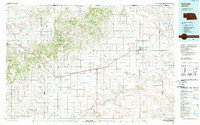
1985 Map of Gordon
USGS Topo · Published 1989About this map
Pine Ridge dominates the northwestern landscape of this mid-1980s survey, marking a dramatic transition between the high plains and the valley floors. This escarpment, protected in part by the Nebraska National Forest, overlooks a series of settlements including Chadron, Hay Springs, and Rushville that align with the vital transportation corridor of U.S. Highway 20 and the Chicago and North Western Railway. These towns served as the commercial hubs for the surrounding ranching and farming operations.
Find a feature on this map
49 named features on this map. Tap any name to fly to it.
Don’t see what you’re looking for? This feature index may not catch every label — zoom into the map to look around manually.
Map Details
Editions of this 1985 Gordon Map
2 editions found
Other maps of this area

1896 · Oelrichs
USGS Topo · 1:125,000

1900 · Oelrichs
USGS Topo · 1:125,000

1947 · Box Butte NE
USGS Topo · 1:24,000

1947 · Box Butte NW
USGS Topo · 1:24,000

1948 · Box Butte Reservoir East
USGS Topo · 1:24,000

1948 · Twin Lakes
USGS Topo · 1:62,500

1948 · Spade Ranch
USGS Topo · 1:62,500

1949 · Box Butte NE
USGS Topo · 1:24,000

1949 · Box Butte NW
USGS Topo · 1:24,000

1949 · Turpin Lake
USGS Topo · 1:62,500