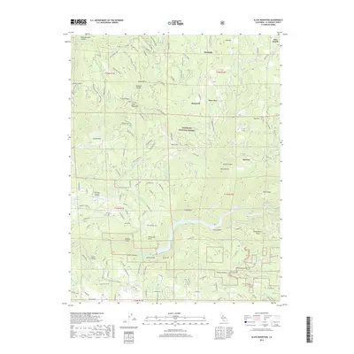
2018 Map of Slate Mountain
USGS Topo · Published 2018About this map
The South Fork American River carves through the southern half of this landscape, anchoring a network of steep canyons and timbered ridges within the Eldorado National Forest. The map documents a transition from the water-rich highlands of Pino Grande and Old Pino to the developed pockets near the Swansboro Country Airport. Water management is central to the area's geography, evidenced by the Finnon Reservoir, Larsen Reservoir, and the small Mill Pond near the southern boundary. Significant topographic features like Slate Mountain, Cable Point, and Independence Point rise above deep drainages such as Long Canyon and Rock Creek. The road network, including the Rock Creek Loop and Cable Road, follows the natural contours of the land, connecting isolated settlements like Fairbanks, Soapweed, and Deer View across the high-elevation terrain.
Find a feature on this map
111 named features on this map. Tap any name to fly to it.
Don’t see what you’re looking for? This feature index may not catch every label — zoom into the map to look around manually.
Map Details
Editions of this 2018 Slate Mountain Map
This is the sole edition of this map. No revisions or reprints were ever made.
Other maps of this area

1891 · Placerville
USGS Topo · 1:125,000

1892 · Placerville
USGS Topo · 1:125,000

1893 · Placerville
USGS Topo · 1:125,000

1947 · Sacramento
USGS Topo · 1:250,000

1948 · Sacramento
USGS Topo · 1:250,000

1949 · Georgetown
USGS Topo · 1:62,500

1949 · Placerville
USGS Topo · 1:62,500
1949 · Georgetown
USGS Topo · 1:24,000

1949 · Placerville
USGS Topo · 1:24,000
1949 · Garden Valley
USGS Topo · 1:24,000