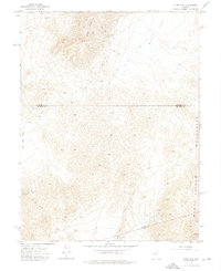
1972 Map of Slate Mtn
USGS Topo · Published 1975About this map
Slate Mine and the Eagleville Mine anchor this early 1970s record of a high-desert mining landscape where Mineral, Churchill, and Nye Counties converge. The topography is dominated by the steep rises of Slate Mountain and the Monte Cristo Mountains, where numerous unnamed prospects flank the established diggings. These industrial sites are linked by a network of unimproved roads and a Jeep Trail that threads through the elevation changes, illustrating the logistical challenges of Great Basin mineral extraction during this era.
Find a feature on this map
15 named features on this map. Tap any name to fly to it.
Don’t see what you’re looking for? This feature index may not catch every label — zoom into the map to look around manually.
Map Details
Editions of this 1972 Slate Mtn Map
2 editions found
Other maps of this area

1908 · Carson Sink
USGS Topo · 1:250,000

1909 · Hawthorne
USGS Topo · 1:250,000

1910 · Carson Sink
USGS Topo · 1:250,000

1911 · Hawthorne
USGS Topo · 1:250,000

1915 · Hawthorne
USGS Topo · 1:250,000

1948 · Walker Lake
USGS Topo · 1:250,000

1957 · Walker Lake
USGS Topo · 1:250,000

1957 · Reno
USGS Topo · 1:250,000

1959 · Reno
USGS Topo · 1:250,000

1960 · Reno
USGS Topo · 1:250,000