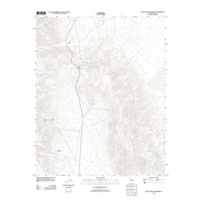
2012 Map of Slate Range Crossing
USGS Topo · Published 2012About this map
Slate Range Crossing serves as a central topographical point in this high-desert landscape of Inyo County, where the terrain is defined by a series of deep drainage systems. The map traces the paths of Water Canyon to the north and the diverging courses of Orondo Canyon and Bruce Canyon to the west. This 2012 survey illustrates the sparse but critical transportation network of the area, featuring Homewood Canyon Rd and Quarry Rd, which provide access to Homewood Canyon. The drainage patterns and road placements indicate a region where geography dictates movement, reflecting the logistical challenges of the California desert. Researchers can observe the specific way modern roads follow the natural contours of the canyons, providing a clear view of the intersection between geology and infrastructure in this portion of the Slate Range.
Find a feature on this map
8 named features on this map. Tap any name to fly to it.
Don’t see what you’re looking for? This feature index may not catch every label — zoom into the map to look around manually.
Map Details
Editions of this 2012 Slate Range Crossing Map
This is the sole edition of this map. No revisions or reprints were ever made.
Other maps of this area

1908 · Ballarat
USGS Topo · 1:250,000

1913 · Ballarat
USGS Topo · 1:250,000

1915 · Searles Lake
USGS Topo · 1:250,000

1947 · Trona
USGS Topo · 1:250,000

1948 · Trona
USGS Topo · 1:250,000

1948 · Death Valley
USGS Topo · 1:250,000

1949 · Trona
USGS Topo · 1:62,500

1950 · Trona
USGS Topo · 1:62,500

1950 · Manly Peak
USGS Topo · 1:62,500
1951 · Manly Peak
USGS Topo · 1:62,500