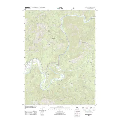
2012 Map of Slater Butte
USGS Topo · Published 2012About this map
The Klamath River carves a deep path through the Klamath National Forest in this 2012 survey, revealing a landscape defined by sharp elevation changes and riverside landings. Small settlements and historic points like Nolton and Fort Goff sit along the riverbanks, marking the interface between the water and the rising terrain of Slater Butte and Cade Mountain. The map illustrates a complex network of forest routes and local roads, such as China Grade Rd and Gordons Ferry Rd, which connect remote holdings like Reeves Ranch to the river corridor. Landforms with distinct names like Shinar Saddle, China Point, and Fryingpan Ridge indicate a geography shaped by both natural forces and early regional activity. Toward the southeast, the landscape becomes increasingly intricate near Three Biscuit Gulch and Evans Mountain, where numerous seasonal creeks like Joe Miles Cr and Wolf Cr drain into the primary river system.
Find a feature on this map
79 named features on this map. Tap any name to fly to it.
Don’t see what you’re looking for? This feature index may not catch every label — zoom into the map to look around manually.
Map Details
Editions of this 2012 Slater Butte Map
This is the sole edition of this map. No revisions or reprints were ever made.
Other maps of this area

1914 · Seiad
USGS Topo · 1:125,000

1922 · Seiad
USGS Topo · 1:125,000

1948 · Weed
USGS Topo · 1:250,000

1950 · Weed
USGS Topo · 1:250,000

1955 · Seiad Valley
USGS Topo · 1:62,500

1955 · Ukonom Lake
USGS Topo · 1:62,500

1955 · Scott Bar
USGS Topo · 1:62,500

1956 · Happy Camp
USGS Topo · 1:62,500

1958 · Weed
USGS Topo · 1:250,000

1963 · Weed
USGS Topo · 1:250,000