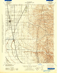
1942 Map of Slater
USGS Topo · Published 1942About this map
Agricultural development and early irrigation systems define this 1942 survey of the San Joaquin Valley floor. The Southern Pacific railroad corridor serves as the primary spine for commerce, linking the major settlement at McFarland with the rail junctions at Famoso and Slater. This era captures a landscape transitioning toward large-scale industrial farming, marked by the extensive reach of the Lerdo Canal and Calloway Canal, and the presence of the Kern County Industrial Farm.
Find a feature on this map
35 named features on this map. Tap any name to fly to it.
Don’t see what you’re looking for? This feature index may not catch every label — zoom into the map to look around manually.
Map Details
Editions of this 1942 Slater Map
This is the sole edition of this map. No revisions or reprints were ever made.
Other maps of this area

1906 · Bakersfield
USGS Topo · 1:62,500

1910 · Buena Vista Lake
USGS Topo · 1:125,000

1912 · Buena Vista Lake
USGS Topo · 1:125,000

1914 · Caliente
USGS Topo · 1:125,000

1926 · Quincy School
USGS Topo · 1:31,680

1927 · McFarland
USGS Topo · 1:31,680

1929 · Delano
USGS Topo · 1:31,680

1929 · Richgrove
USGS Topo · 1:31,680

1929 · Quincy School
USGS Topo · 1:31,680

1929 · Stone
USGS Topo · 1:31,680