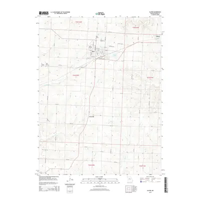
2015 Map of Slater
USGS Topo · Published 2015About this map
The railroad-influenced layout of Slater dominates the northern landscape of this Missouri quadrangle, where a grid of streets like N Broadway Ave and Commercial Ave meet the industrial corridor of Industrial Blvd. Beyond the city center, the terrain is defined by the headwaters of numerous small streams including Rock Creek and Thrailkill Br, which carve through the agricultural fields of Saline County.
Find a feature on this map
63 named features on this map. Tap any name to fly to it.
Don’t see what you’re looking for? This feature index may not catch every label — zoom into the map to look around manually.
Map Details
Editions of this 2015 Slater Map
This is the sole edition of this map. No revisions or reprints were ever made.
Other maps of this area

1890 · Glasgow
USGS Topo · 1:125,000

1890 · Marshall
USGS Topo · 1:125,000

1892 · Marshall
USGS Topo · 1:125,000

1901 · Marshall
USGS Topo · 1:125,000

1940 · Marshall
USGS Topo · 1:62,500

1944 · Marshall
USGS Topo · 1:62,500

1947 · Glasgow
USGS Topo · 1:62,500

1951 · Miami
USGS Topo · 1:24,000
1951 · New Frankfort
USGS Topo · 1:24,000

1953 · Moberly
USGS Topo · 1:250,000