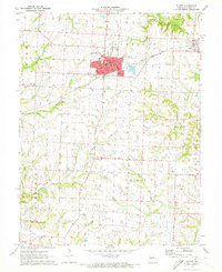
1971 Map of Slater
USGS Topo · Published 1973About this map
Slater serves as the primary hub of this Saline County landscape, its street grid and urban footprint clearly defined against the surrounding agricultural terrain. The Gulf Mobile and Ohio railroad cuts across the northern half of the sheet, providing a direct industrial link between the residential core of Slater and the nearby town of Gilliam. This transport corridor reflects the era’s reliance on rail for moving goods through Missouri’s farming heartland.
Find a feature on this map
21 named features on this map. Tap any name to fly to it.
Don’t see what you’re looking for? This feature index may not catch every label — zoom into the map to look around manually.
Map Details
Editions of this 1971 Slater Map
This is the sole edition of this map. No revisions or reprints were ever made.
Other maps of this area

1890 · Glasgow
USGS Topo · 1:125,000

1890 · Marshall
USGS Topo · 1:125,000

1892 · Marshall
USGS Topo · 1:125,000

1901 · Marshall
USGS Topo · 1:125,000

1940 · Marshall
USGS Topo · 1:62,500

1944 · Marshall
USGS Topo · 1:62,500

1947 · Glasgow
USGS Topo · 1:62,500

1951 · Miami
USGS Topo · 1:24,000
1951 · New Frankfort
USGS Topo · 1:24,000

1953 · Moberly
USGS Topo · 1:250,000