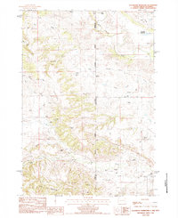
1984 Map of Slaughter Reservoir
USGS Topo · Published 1984About this map
Uranium Mines and scattered ranching operations define this high-plains landscape along the border of Wyoming and South Dakota. In the mid-1980s, the area was a network of family-named holdings like Budmayr Ranch, Osloond Ranch, and Heimer Ranch, connected by improved and unimproved routes such as Mona Road. The Belle Fourche River winds through the northern portion of the quadrangle, joined by complex drainage systems including Grummit Canyon and Hay Creek. The topography is particularly striking in the south, where the drainage divides at The Forks give way to the complex, eroded terrain of The Brakes. Water management is central to life here, evidenced by the numerous flowing wells and the Slaughter Reservoir, which serves as a critical landmark in this arid territory at the edge of the Black Hills.
Find a feature on this map
41 named features on this map. Tap any name to fly to it.
Don’t see what you’re looking for? This feature index may not catch every label — zoom into the map to look around manually.
Map Details
Editions of this 1984 Slaughter Reservoir Map
This is the sole edition of this map. No revisions or reprints were ever made.
Other maps of this area

1901 · Aladdin
USGS Topo · 1:125,000

1903 · Aladdin
USGS Topo · 1:125,000

1905 · Indian
USGS Topo · 1:62,500

1907 · Belle Fourche
USGS Topo · 1:125,000

1907 · Redwater
USGS Topo · 1:62,500

1953 · Rapid City
USGS Topo · 1:250,000

1954 · The Forks
USGS Topo · 1:24,000

1954 · Gillette
USGS Topo · 1:250,000

1955 · Gillette
USGS Topo · 1:250,000

1957 · Rapid City
USGS Topo · 1:250,000