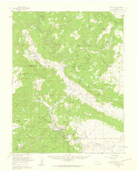
1960 Map of Slick Rock
USGS Topo · Published 1961About this map
The Dolores River winds through this 1960 survey of San Miguel County, carving a dramatic serpentine path through a landscape defined by uranium and vanadium mining. This era was the height of the regional mining boom, evidenced by the dense cluster of claims such as the Joe Dandy Mine, Bachelor Mine, and the Peanut No 3 Mine scattered across Monogram Mesa and the Grassy Hills. Small residential hubs and camps supported the industry, including Bachelor Camp and the isolated Indian Henrys Cabin.
Find a feature on this map
100 named features on this map. Tap any name to fly to it.
Don’t see what you’re looking for? This feature index may not catch every label — zoom into the map to look around manually.
Map Details
Editions of this 1960 Slick Rock Map
2 editions found
Other maps of this area

1885 · La Sal
USGS Topo · 1:250,000

1886 · Abajo
USGS Topo · 1:250,000

1892 · Abajo
USGS Topo · 1:250,000

1893 · Abajo
USGS Topo · 1:250,000

1916 · Paradox Valley
USGS Topo · 1:125,000

1922 · Paradox Valley
USGS Topo · 1:125,000

1948 · Bull Canyon
USGS Topo · 1:24,000

1948 · Horse Range Mesa
USGS Topo · 1:24,000

1948 · Uravan
USGS Topo · 1:24,000

1948 · Hamm Canyon
USGS Topo · 1:24,000