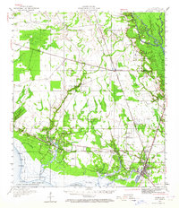
1950 Map of Slidell
USGS Topo · Published 1964About this map
Slidell and its surrounding wetlands are shown at a pivotal mid-century moment before the expansion of the modern interstate system changed the character of ST Tammany Parish. The landscape is dominated by a complex network of waterways, including Bayou Lacombe, Bayou Liberty, and Bayou Bonfouca, which flow south into Lake Pontchartrain. The transportation of the era is defined by the Gulf Mobile and Ohio and Southern Railway lines, which supported timber and transport through small stops like Bonfouca Sta and St Tammany Corner. Inland, the community fabric is preserved through rural landmarks like Evans Creek Ch, Peace Grove Ch, and the Forest Glen School. Extensive natural preserves, including the St Tammany State Game Forest and a State Game Refuge near Goose Pt, emphasize the enduring coastal marsh and bottomland hardwood environment of the north shore.
Find a feature on this map
59 named features on this map. Tap any name to fly to it.
Don’t see what you’re looking for? This feature index may not catch every label — zoom into the map to look around manually.
Map Details
Editions of this 1950 Slidell Map
2 editions found

Other maps of this area

1891 · Spanish Fort
USGS Topo · 1:62,500

1892 · Chef Menteur
USGS Topo · 1:62,500

1893 · Rigolets
USGS Topo · 1:62,500

1914 · Nicholson
USGS Topo · 1:62,500

1921 · Nicholson
USGS Topo · 1:62,500

1935 · Slidell
USGS Topo · 1:62,500

1935 · Covington
USGS Topo · 1:62,500

1936 · North Shore
USGS Topo · 1:31,680

1936 · South Point
USGS Topo · 1:31,680

1936 · Chef Menteur
USGS Topo · 1:62,500