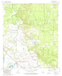
1980 Map of Sligo
USGS Topo · Published 1980About this map
The Red River and Red Chute Bayou dominate this landscape southeast of Bossier City, carving a complex network of oxbows and bends such as Buzzard Roost Bend and Cane Bend. The 1980 landscape is defined by the intersection of military, industrial, and rural interests, with the southern reaches of Barksdale Air Force Base occupying the northern half of the area. Below the base, the Sligo Oil and Gas Field indicates the subsurface economy that transformed this region.
Find a feature on this map
50 named features on this map. Tap any name to fly to it.
Don’t see what you’re looking for? This feature index may not catch every label — zoom into the map to look around manually.
Map Details
Editions of this 1980 Sligo Map
This is the sole edition of this map. No revisions or reprints were ever made.
Other maps of this area

1932 · Bossier SE
USGS Topo · 1:31,680

1932 · Bossier SW
USGS Topo · 1:31,680

1938 · Arnsberg
USGS Topo · 1:31,680

1941 · Forbing
USGS Topo · 1:31,680

1941 · Bossier Point
USGS Topo · 1:31,680

1947 · Ringgold
USGS Topo · 1:62,500

1947 · Minden
USGS Topo · 1:62,500

1948 · Bossier City
USGS Topo · 1:62,500

1948 · Caspiana
USGS Topo · 1:62,500

1949 · Minden
USGS Topo · 1:62,500