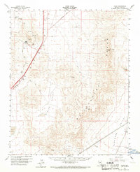
1960 Map of Sloan
USGS Topo · Published 1967About this map
The Union Pacific railroad corridor serves as the primary artery through this desert landscape at the start of the 1960s, connecting a string of small rail-side points. The settlement of Sloan stands as a focal point for local activity, surrounded by several Quarries and a Gravel Pit that highlight the area's industrial importance. Further along the tracks, the map identifies Arden and Erie, alongside the location of Bard (Site), marking the evolution of these desert outposts over time.
Find a feature on this map
17 named features on this map. Tap any name to fly to it.
Don’t see what you’re looking for? This feature index may not catch every label — zoom into the map to look around manually.
Map Details
Editions of this 1960 Sloan Map
3 editions found
Other maps of this area

1886 · Camp Mohave
USGS Topo · 1:250,000

1886 · Saint Thomas
USGS Topo · 1:250,000

1892 · Camp Mohave
USGS Topo · 1:250,000

1893 · Saint Thomas
USGS Topo · 1:250,000

1907 · Las Vegas
USGS Topo · 1:250,000

1908 · Las Vegas
USGS Topo · 1:250,000

1910 · Ivanpah
USGS Topo · 1:250,000

1912 · Ivanpah
USGS Topo · 1:250,000

1926 · Nelson
USGS Topo · 1:96,000

1926 · Boulder Canyon
USGS Topo · 1:96,000