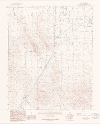
1989 Map of Sloan
USGS Topo · Published 1990About this map
Industrial extraction and desert transportation converge at Sloan, where the landscape is defined by extensive limestone and mineral operations including multiple Quarry sites and associated Tailings. The infrastructure of the late 1980s is visible in the Union Pacific rail line and various utility corridors, including a Trans Line and Pipeline. To the north, the Henderson Corporate Boundary marks the edge of suburban expansion near the Las Vegas-Henderson Sky Harbor Airport. The rugged eastern terrain is dominated by the peaks of the Mc Cullough Range, which gives way to the relatively flat expanse of Hidden Valley. Notable for local history, the map identifies the former location of Bard (Site) along the railway, serving as a record of early desert outposts that have since faded into the landscape.
Find a feature on this map
19 named features on this map. Tap any name to fly to it.
Don’t see what you’re looking for? This feature index may not catch every label — zoom into the map to look around manually.
Map Details
Editions of this 1989 Sloan Map
2 editions found
Other maps of this area

1907 · Las Vegas
USGS Topo · 1:250,000

1908 · Las Vegas
USGS Topo · 1:250,000

1910 · Ivanpah
USGS Topo · 1:250,000

1912 · Ivanpah
USGS Topo · 1:250,000

1942 · Ivanpah
USGS Topo · 1:250,000

1947 · Kingman
USGS Topo · 1:250,000

1948 · Kingman
USGS Topo · 1:250,000

1952 · Blue Diamond
USGS Topo · 1:62,500

1952 · Las Vegas
USGS Topo · 1:62,500

1954 · Las Vegas
USGS Topo · 1:250,000