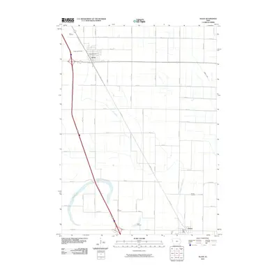
2010 Map of Sloan
USGS Topo · Published 2010About this map
The agrarian landscape of Woodbury County is defined here by a systematic network of drainage infrastructure, most notably Farmers Ditch, Boyer Ditch, and the McCandless Cleghorn Ditch. These man-made channels crisscross the flat terrain surrounding the primary settlements of Sloan and Whiting, which are anchored by their respective civic centers at the Sloan Post Office and Whiting Post Office. This 2010 survey illustrates the persistence of small-town Iowa layout, where local life remains clustered around central hubs while the surrounding countryside is partitioned into precise grids by roads like Dallas Ave and Cashew Ave.
Find a feature on this map
48 named features on this map. Tap any name to fly to it.
Don’t see what you’re looking for? This feature index may not catch every label — zoom into the map to look around manually.
Map Details
Editions of this 2010 Sloan Map
This is the sole edition of this map. No revisions or reprints were ever made.
Other maps of this area

1955 · Sioux City
USGS Topo · 1:250,000

1958 · Sioux City
USGS Topo · 1:250,000

1959 · Sioux City
USGS Topo · 1:250,000

1964 · Climbing Hill
USGS Topo · 1:24,000

1964 · Luton
USGS Topo · 1:24,000

1964 · Salix
USGS Topo · 1:24,000

1966 · Macy
USGS Topo · 1:24,000

1969 · Onawa
USGS Topo · 1:24,000

1969 · Albaton
USGS Topo · 1:24,000
1969 · Hornick
USGS Topo · 1:24,000