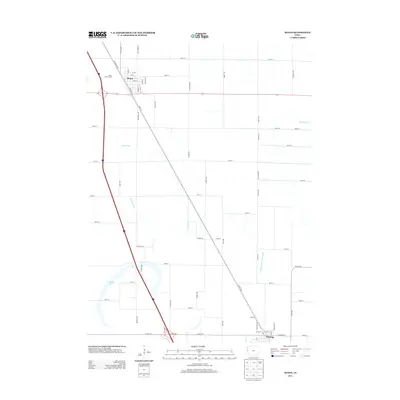
2013 Map of Sloan
USGS Topo · Published 2013About this map
Sloan and Whiting anchor this section of the Missouri River floodplain, where the landscape is defined by an extensive network of engineered drainage. The map details a complex system of water management including Boyer Ditch, Swanson Ditch, and the McCandless Cleghorn Ditch, illustrating how the low-lying terrain has been modified for agricultural use. While the modern interstate corridor runs through the western portion, the persistence of Old Highway 75 and a grid of local avenues like Dallas Ave and Delaware Ave reflect the region's long-standing rural road hierarchy. In the northern reaches, the Sloan Golf Course provides a distinct break from the surrounding fields. Further south, the presence of Badger Lake offers a glimpse of the natural hydrology that existed before the widespread implementation of the drainage ditches that now crisscross the township lines.
Find a feature on this map
65 named features on this map. Tap any name to fly to it.
Don’t see what you’re looking for? This feature index may not catch every label — zoom into the map to look around manually.
Map Details
Editions of this 2013 Sloan Map
This is the sole edition of this map. No revisions or reprints were ever made.
Other maps of this area

1955 · Sioux City
USGS Topo · 1:250,000

1958 · Sioux City
USGS Topo · 1:250,000

1959 · Sioux City
USGS Topo · 1:250,000

1964 · Climbing Hill
USGS Topo · 1:24,000

1964 · Luton
USGS Topo · 1:24,000

1964 · Salix
USGS Topo · 1:24,000

1966 · Macy
USGS Topo · 1:24,000

1969 · Onawa
USGS Topo · 1:24,000

1969 · Albaton
USGS Topo · 1:24,000
1969 · Hornick
USGS Topo · 1:24,000