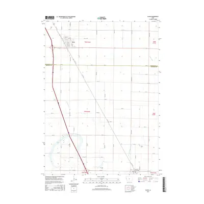
2015 Map of Sloan
USGS Topo · Published 2015About this map
Sloan serves as the primary hub of this 2015 survey, situated at the intersection of a vast agricultural grid and the modern transportation corridors of western Iowa. The landscape is defined by its complex drainage network, which includes the Boyer Ditch, Swanson Ditch, and the notably long McCandless Cleghorn Ditch. These man-made channels highlight the region's historical transformation of the Missouri River floodplain into productive farmland. Near the western edge, Badger Lake remains a significant natural hydrographic feature amidst the square-mile sections of Woodbury and Monona Counties. For genealogists and local historians, the map identifies several rural burial sites, such as the Sloan Cem, Hite Cem, and Clark Cem, providing exact locations for family research. The survey captures the area at a time when traditional section roads like 340th St and Buckley St integrated with larger regional routes such as Co Hwy K45.
Find a feature on this map
69 named features on this map. Tap any name to fly to it.
Don’t see what you’re looking for? This feature index may not catch every label — zoom into the map to look around manually.
Map Details
Editions of this 2015 Sloan Map
This is the sole edition of this map. No revisions or reprints were ever made.
Other maps of this area

1955 · Sioux City
USGS Topo · 1:250,000

1958 · Sioux City
USGS Topo · 1:250,000

1959 · Sioux City
USGS Topo · 1:250,000

1964 · Climbing Hill
USGS Topo · 1:24,000

1964 · Luton
USGS Topo · 1:24,000

1964 · Salix
USGS Topo · 1:24,000

1966 · Macy
USGS Topo · 1:24,000

1969 · Onawa
USGS Topo · 1:24,000

1969 · Albaton
USGS Topo · 1:24,000
1969 · Hornick
USGS Topo · 1:24,000