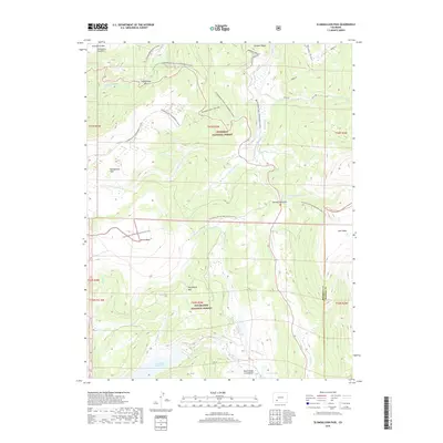
2019 Map of Slumgullion Pass
USGS Topo · Published 2019About this map
The geologic mass movement of the Slumgullion Slide and Slumgullion Earthflow dominates the northern high-country landscape near the Hinsdale and Mineral County line. This 2019 survey captures the drainage patterns and recreational routes within the Gunnison National Forest and Rio Grande National Forest. The Continental Divide National Scenic Trail winds across high-elevation features like Jarosa Mesa and Snow Mesa, providing a clear record of this high mountain corridor. In the southern portion of the quadrangle, water resources such as Continental Reservoir and Pointer Lake sit at the confluence of several high-altitude drainages, including Rito Hondo Cr and N Clear Cr. Specialized winter use is highlighted by numerous snowmobile routes like the Rambouillet Snowmobile and Cebolla Snowmobile trails, illustrating how modern recreational access is mapped alongside traditional topographic features like Horsethief Mtn.
Find a feature on this map
31 named features on this map. Tap any name to fly to it.
Don’t see what you’re looking for? This feature index may not catch every label — zoom into the map to look around manually.
Map Details
Editions of this 2019 Slumgullion Pass Map
This is the sole edition of this map. No revisions or reprints were ever made.
Other maps of this area

1903 · Lake City
USGS Topo · 1:62,500

1905 · Lake City
USGS Topo · 1:62,500

1905 · San Cristobal
USGS Topo · 1:125,000

1907 · San Cristobal
USGS Topo · 1:125,000

1908 · Uncompahgre
USGS Topo · 1:125,000

1911 · Uncompahgre
USGS Topo · 1:125,000

1945 · Durango
USGS Topo · 1:250,000

1953 · Durango
USGS Topo · 1:250,000

1954 · Durango
USGS Topo · 1:250,000

1956 · Montrose
USGS Topo · 1:250,000