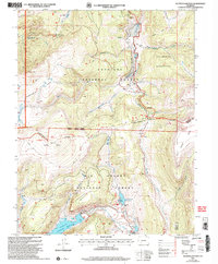
2001 Map of Slumgullion Pass
USGS Topo · Published 2005About this map
Slumgullion Pass and Spring Creek Pass serve as the primary gateways through this high-altitude landscape where the Gunnison National Forest meets the Rio Grande National Forest. The geography is defined by the Continental Divide, which snakes through the center of the sheet, separating the waters of the Slumgullion Creek drainage from the southern catchments near Continental Reservoir. A remarkable geological feature, the Slumgullion Slide, is documented here alongside high plateaus like Snow Mesa and Jarosa Mesa.
Find a feature on this map
26 named features on this map. Tap any name to fly to it.
Don’t see what you’re looking for? This feature index may not catch every label — zoom into the map to look around manually.
Map Details
Editions of this 2001 Slumgullion Pass Map
This is the sole edition of this map. No revisions or reprints were ever made.
Other maps of this area

1903 · Lake City
USGS Topo · 1:62,500

1905 · Lake City
USGS Topo · 1:62,500

1905 · San Cristobal
USGS Topo · 1:125,000

1907 · San Cristobal
USGS Topo · 1:125,000

1908 · Uncompahgre
USGS Topo · 1:125,000

1911 · Uncompahgre
USGS Topo · 1:125,000

1945 · Durango
USGS Topo · 1:250,000

1953 · Durango
USGS Topo · 1:250,000

1954 · Durango
USGS Topo · 1:250,000

1956 · Montrose
USGS Topo · 1:250,000