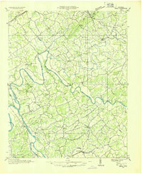
1935 Map of Small
USGS Topo · Published 1935About this map
The French Broad River and Nolichucky River define this 1935 landscape at the intersection of Cocke, Greene, and Hamblen counties. Compiled from aerial photographs, this study by the Tennessee Valley Authority and USGS reveals a highly developed rural network of river crossings and small community centers. Extensive fertile tracts like Irish Bottoms are connected by landmarks such as Conway Bridge and Hale Bridge, while the Southern Railway supports the economy at Mohawk, where the Mohawk Roller Mill stands as a focal point of local industry.
Find a feature on this map
91 named features on this map. Tap any name to fly to it.
Don’t see what you’re looking for? This feature index may not catch every label — zoom into the map to look around manually.
Map Details
Editions of this 1935 Small Map
This is the sole edition of this map. No revisions or reprints were ever made.
Other maps of this area

1883 · Morristown
USGS Topo · 1:125,000

1892 · Greeneville
USGS Topo · 1:125,000

1893 · Mt Guyot
USGS Topo · 1:125,000

1893 · Morristown
USGS Topo · 1:125,000

1894 · Asheville
USGS Topo · 1:125,000

1895 · Morristown
USGS Topo · 1:125,000

1896 · Greeneville
USGS Topo · 1:125,000

1901 · Asheville
USGS Topo · 1:125,000

1904 · Greeneville
USGS Topo · 1:125,000

1912 · Mt Guyot
USGS Topo · 1:125,000