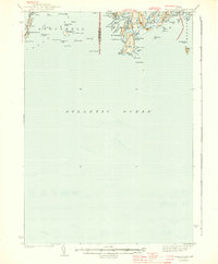
1944 Map of Small Point
USGS Topo · Published 1944About this map
The rocky coastline of Phippsburg and Harpswell is defined by a jagged network of islands and peninsulas as they appeared in 1941. This maritime landscape centers on Small Point Harbor and the narrow straits of Casco Bay, where the surveying work of B.P. Taylor and J.A. Mattingly captures a community deeply tied to the Atlantic. Notable elevations like Morse Mtn rise above the surrounding marshes and tidal pools, while the coastline is peppered with distinctive navigational landmarks such as Bold Dick, White Bull, and the Cedar Ledges. The transition from the mainland to the islands is marked by Bailey Island and the neighboring Ragged I, illustrating the scattered nature of settlement along this stretch of the Maine coast. Detailed surveying of Atkins Bay and Jaquish Cut reveals the intricate waterways used by local mariners before modern development altered the shoreline.
Find a feature on this map
71 named features on this map. Tap any name to fly to it.
Don’t see what you’re looking for? This feature index may not catch every label — zoom into the map to look around manually.
Map Details
Editions of this 1944 Small Point Map
3 editions found

Other maps of this area

1892 · Freeport
USGS Topo · 1:62,500

1893 · Small Point
USGS Topo · 1:62,500

1893 · Casco Bay
USGS Topo · 1:62,500

1893 · Boothbay
USGS Topo · 1:62,500

1894 · Bath
USGS Topo · 1:62,500

1914 · Casco Bay
USGS Topo · 1:48,000

1916 · Casco Bay
USGS Topo · 1:62,500

1916 · Portland And Vicinity
USGS Topo · 1:62,500

1918 · Portland And Vicinity
USGS Topo · 1:62,500

1919 · Small Point
USGS Topo · 1:62,500