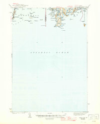
1944 Map of Small Point
USGS Topo · Published 1947About this map
Bailey Island and the neighboring Orrs I stand as prominent landmarks at the western edge of this 1940s survey, marking the transition from Casco Bay into the Atlantic. The coastline of Phippsburg and Georgetown reveals a landscape defined by jagged fingers of land, where tidal rivers like the Morse River and Sprague River carve through the granite terrain. The proximity of Popham Beach to Sabino Hill and Spirit Pond illustrates the historical importance of these coastal nodes for maritime navigation and early settlement.
Find a feature on this map
70 named features on this map. Tap any name to fly to it.
Don’t see what you’re looking for? This feature index may not catch every label — zoom into the map to look around manually.
Map Details
Editions of this 1944 Small Point Map
3 editions found

Other maps of this area

1892 · Freeport
USGS Topo · 1:62,500

1893 · Small Point
USGS Topo · 1:62,500

1893 · Casco Bay
USGS Topo · 1:62,500

1893 · Boothbay
USGS Topo · 1:62,500

1894 · Bath
USGS Topo · 1:62,500

1914 · Casco Bay
USGS Topo · 1:48,000

1916 · Casco Bay
USGS Topo · 1:62,500

1916 · Portland And Vicinity
USGS Topo · 1:62,500

1918 · Portland And Vicinity
USGS Topo · 1:62,500

1919 · Small Point
USGS Topo · 1:62,500