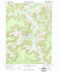
1969 Map of Smethport
USGS Topo · Published 1972About this map
Smethport serves as the hub of this McKean County landscape, where the confluence of Marvin Creek and Potato Creek shaped the early valley floor. By the late 1960s, the borough remained a center of local activity, featuring the High Sch and the County Fairgrounds just east of town. The surrounding hills are marked by numerous oil wells, particularly within the Sartwell Oil Field to the northeast, reflecting the region's long-standing petroleum industry. Transportation is defined by the Penn Central rail lines following the watercourses through Farmers Valley and past the Sewage Disposal plant. Topographical landmarks like The Nipple and Prospect Hill rise above the many hollows—such as Gifford Hollow and Irish Hollow—that segment the terrain. Genealogists will find the locations of Smith Hill Cem and St Elizabeths Cem useful for local family research.
Find a feature on this map
47 named features on this map. Tap any name to fly to it.
Don’t see what you’re looking for? This feature index may not catch every label — zoom into the map to look around manually.
Map Details
Editions of this 1969 Smethport Map
This is the sole edition of this map. No revisions or reprints were ever made.
Other maps of this area

1924 · Bradford
USGS Topo · 1:62,500

1926 · Bradford
USGS Topo · 1:62,500

1933 · Smethport
USGS Topo · 1:62,500

1935 · Mt. Jewett
USGS Topo · 1:48,000

1937 · Smethport
USGS Topo · 1:62,500

1940 · Mt. Jewett
USGS Topo · 1:62,500

1941 · Bradford
USGS Topo · 1:62,500

1944 · Bradford
USGS Topo · 1:62,500

1948 · Crosby
USGS Topo · 1:62,500

1948 · Norwich
USGS Topo · 1:24,000