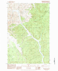
1983 Map of Smith Creek Butte
USGS Topo · Published 1984About this map
The Mount St. Helens National Volcanic Monument and Gifford Pinchot National Forest dominate this 1983 survey, documenting the landscape in the immediate aftermath of the 1980 eruption. The map serves as a primary source for the event's environmental impact, explicitly marking the Eruption Impact Line and vast areas of Blowdown where the lateral blast leveled the standing timber. These forensic details contrast with the enduring terrain of Smith Creek Butte and the rugged drainage systems of the Muddy River and Clearwater Creek.
Find a feature on this map
17 named features on this map. Tap any name to fly to it.
Don’t see what you’re looking for? This feature index may not catch every label — zoom into the map to look around manually.
Map Details
Editions of this 1983 Smith Creek Butte Map
This is the sole edition of this map. No revisions or reprints were ever made.
Other maps of this area

1919 · Mount St Helens
USGS Topo · 1:125,000

1926 · Steamboat Mtn
USGS Topo · 1:125,000

1931 · Steamboat Mtn
USGS Topo · 1:125,000

1950 · Yakima
USGS Topo · 1:250,000

1953 · Hoquiam
USGS Topo · 1:250,000

1957 · Hoquiam
USGS Topo · 1:250,000

1957 · Spirit Lake
USGS Topo · 1:62,500

1958 · Mt St. Helens
USGS Topo · 1:62,500

1958 · Yakima
USGS Topo · 1:250,000

1958 · Hoquiam
USGS Topo · 1:250,000