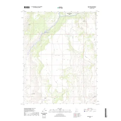
2020 Map of Smith Mesa
USGS Topo · Published 2020About this map
La Verkin and Virgin anchor the southwestern corner of this topographical study, where the landscape dramatically rises toward the high plateaus of southwest Utah. The drainage of the Virgin Wild and Scenic River carves through the terrain, flanked by the massive elevations of Hurricane Mesa and the expansive Smith Mesa. This 2020 map documents the complex relationship between the low-lying settlements and the sheer verticality of the Hurricane Cliffs and Black Ridge. To the north, the boundary of Zion National Park reaches into the area near Red Butte, while a network of rural routes like Smith Mesa Rd and Kolob Reservoir Rd provide access to the remote uplands and the eastern Cave Valley. Local water sources such as Rock Spring and La Verkin Cr define the few corridors through this intensely vertical environment.
Find a feature on this map
19 named features on this map. Tap any name to fly to it.
Don’t see what you’re looking for? This feature index may not catch every label — zoom into the map to look around manually.
Map Details
Editions of this 2020 Smith Mesa Map
This is the sole edition of this map. No revisions or reprints were ever made.
Other maps of this area

1885 · St. George
USGS Topo · 1:250,000

1891 · St. George
USGS Topo · 1:250,000

1953 · Cedar City
USGS Topo · 1:250,000

1954 · La Verkin 4 NW
USGS Topo · 1:24,000

1954 · La Verkin 3 NE
USGS Topo · 1:24,000

1954 · La Verkin 1 SW
USGS Topo · 1:24,000

1954 · La Verkin 2 SE
USGS Topo · 1:24,000

1954 · Hurricane
USGS Topo · 1:62,500

1957 · New Harmony
USGS Topo · 1:62,500

1958 · Cedar City
USGS Topo · 1:250,000