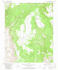
1980 Map of Smith Mesa
USGS Topo · Published 1980About this map
Smith Mesa dominates this 1980 survey, showing the dramatic transition between high plateau country and the Hurricane Cliffs in Washington County. The map details a landscape where traditional cattle ranching features like Lamareaux Tank and various springs exist alongside mid-century technical installations. Most notable is the specialized infrastructure on Hurricane Mesa, including a Landing Strip and a Test Track perched atop the flat-topped landform.
Find a feature on this map
28 named features on this map. Tap any name to fly to it.
Don’t see what you’re looking for? This feature index may not catch every label — zoom into the map to look around manually.
Map Details
Editions of this 1980 Smith Mesa Map
This is the sole edition of this map. No revisions or reprints were ever made.
Other maps of this area

1885 · St. George
USGS Topo · 1:250,000

1891 · St. George
USGS Topo · 1:250,000

1953 · Cedar City
USGS Topo · 1:250,000

1954 · La Verkin 4 NW
USGS Topo · 1:24,000

1954 · La Verkin 3 NE
USGS Topo · 1:24,000

1954 · La Verkin 1 SW
USGS Topo · 1:24,000

1954 · La Verkin 2 SE
USGS Topo · 1:24,000

1954 · Hurricane
USGS Topo · 1:62,500

1957 · New Harmony
USGS Topo · 1:62,500

1958 · Cedar City
USGS Topo · 1:250,000