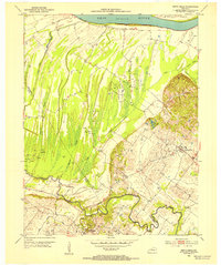
1952 Map of Smith Mills
USGS Topo · Published 1954About this map
The Ohio River bottomlands south of Diamond Island define the landscape of this 1950s survey, where the border between Henderson and Union Counties follows the winding path of Highland Creek. This era reveals a region where the traditional agriculture of settlements like Smith Mills and Alzey was increasingly punctuated by industrial activity, as evidenced by the numerous Oil Wells scattered across the lowlands and the Cabel Hills. The drainage pattern is particularly intricate, featuring a network of sloughs such as Fishitrap Slough, Hogan Slough, and Mill Pond Slough that speak to the wet, alluvial nature of the terrain. Local genealogy is anchored by landmarks like St Francis Ch and the Smith Mills Cem, providing a clear view of the rural social centers near Hitesville before modern expansion altered the footprint of these river communities.
Find a feature on this map
23 named features on this map. Tap any name to fly to it.
Don’t see what you’re looking for? This feature index may not catch every label — zoom into the map to look around manually.
Map Details
Editions of this 1952 Smith Mills Map
2 editions found
Other maps of this area

1906 · Sebree
USGS Topo · 1:62,500

1907 · Morganfield
USGS Topo · 1:62,500

1914 · Henderson
USGS Topo · 1:48,000

1916 · Henderson
USGS Topo · 1:62,500

1917 · Uniontown
USGS Topo · 1:62,500

1949 · Morganfield
USGS Topo · 1:24,000

1949 · Poole
USGS Topo · 1:24,000

1951 · Poole
USGS Topo · 1:24,000

1951 · Waverly
USGS Topo · 1:24,000
1951 · Morganfield
USGS Topo · 1:24,000