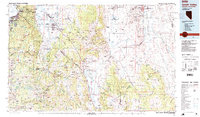
1985 Map of Smith Valley
USGS Topo · Published 1985About this map
The Wassuk Range and Pine Nut Mountains dominate this 1985 mid-century landscape where the agricultural valleys of western Nevada meet the high Sierra Nevada. In the western reaches, Lake Tahoe defines the shoreline near South Lake Tahoe and Stateline, while the East Fork Carson River and West Fork Carson River irrigate the productive ranching lands around Minden and Gardnerville. The map documents a complex mix of land uses, from the Washoe Indian Res to the mineral-rich slopes containing the Leviathan Mine and the Blue Danub Mine. Resource management is evident through the Lahontan National Fish Hatchery and the protected lands of the Toiyabe National Forest. The transition from the high peaks like Freel Peak to the basin floors of Antelope Valley and Smith Valley illustrates the region's diverse hydrology, punctuated by the Artesia Lake state wildlife area and the engineering of the Kinney Reservoir.
Find a feature on this map
106 named features on this map. Tap any name to fly to it.
Don’t see what you’re looking for? This feature index may not catch every label — zoom into the map to look around manually.
Map Details
Editions of this 1985 Smith Valley Map
2 editions found
Other maps of this area

1889 · Pyramid Peak
USGS Topo · 1:125,000

1889 · Markleeville
USGS Topo · 1:125,000

1891 · Carson
USGS Topo · 1:125,000

1891 · Markleeville
USGS Topo · 1:125,000

1891 · Truckee
USGS Topo · 1:125,000

1891 · Big Trees
USGS Topo · 1:125,000

1891 · Wabuska
USGS Topo · 1:125,000

1891 · Pyramid Peak
USGS Topo · 1:125,000

1891 · Wellington
USGS Topo · 1:125,000

1893 · Carson
USGS Topo · 1:125,000