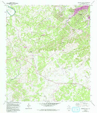
1964 Map of Smithson Valley
USGS Topo · Published 1994About this map
Canyon Lake defines the northeastern corner of this Texas Hill Country survey, which shows the area during a period of transition and growth. The map tracks the expansion of residential developments like Canyon Lake Forest and Westhaven near the water, while the interior remains defined by traditional ranching landscapes and scattered family homesteads. Cultural and genealogical history is preserved in the numerous small burial grounds found throughout the terrain, including Rust Cem, Jonas Cem, and Cranes Mill Cem. The local infrastructure of Smithson Valley is anchored by Smithson Valley High Sch and a network of named routes such as Cranes Mill Road and Rebecca Creek Road. Multiple gravel pits and the presence of Dripping Springs and Smithson Springs highlight the geological and hydrological character of the Dry Comal Creek and Guadalupe River basins.
Find a feature on this map
45 named features on this map. Tap any name to fly to it.
Don’t see what you’re looking for? This feature index may not catch every label — zoom into the map to look around manually.
Map Details
Editions of this 1964 Smithson Valley Map
3 editions found
Other maps of this area

1920 · Smithsons Valley
USGS Topo · 1:62,500

1925 · Hunter No 3
USGS Topo · 1:48,000

1925 · Smithson Valley No. 1
USGS Topo · 1:48,000

1927 · New Braunfels
USGS Topo · 1:62,500

1927 · Smithson Valley
USGS Topo · 1:62,500

1929 · Hunter
USGS Topo · 1:62,500

1929 · Smithson Valley
USGS Topo · 1:62,500

1940 · Smithson Valley
USGS Topo · 1:62,500

1953 · Bulverde
USGS Topo · 1:24,000

1953 · Bat Cave
USGS Topo · 1:24,000