
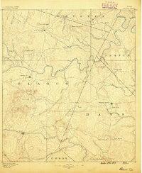
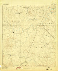
1925 Map of Smithson Valley No. 1
USGS Topo · Published 1925About this map
The Guadalupe River carves a dramatic, winding course across this 1920s Texas landscape, creating prominent natural features like Demi John Bend and Cordova Bend. This area of Comal and Blanco counties reflects a rural Texas economy centered on local gathering points such as Fischer Store and Cranes Mill. The map documents a moment in time before large-scale regional development, when travel relied on routes like the New Braunfels Road and education was decentralized among community institutions like the Rebecca Creek School and Sour Creek School. The topography reveals the natural river hazards of the era, including Rust Falls and Rough Falls, alongside several smaller tributaries including Rebecca Creek and Schultz Creek. This survey, which utilized early aerial photography by the U.S. Army Air Service, provides a meticulous record of land use and settlement patterns along the river valley.
Find a feature on this map
19 named features on this map. Tap any name to fly to it.
Don’t see what you’re looking for? This feature index may not catch every label — zoom into the map to look around manually.
Map Details
Editions of this 1925 Smithson Valley No. 1 Map
This is the sole edition of this map. No revisions or reprints were ever made.
Other maps of this area
1887 · Blanco
USGS Topo · 1:125,000
1894 · Blanco
USGS Topo · 1:125,000

1920 · Smithsons Valley
USGS Topo · 1:62,500

1925 · Hunter No 3
USGS Topo · 1:48,000

1927 · Smithson Valley
USGS Topo · 1:62,500
1929 · Hunter
USGS Topo · 1:62,500

1929 · Smithson Valley
USGS Topo · 1:62,500

1940 · Smithson Valley
USGS Topo · 1:62,500

1954 · Llano
USGS Topo · 1:250,000

1954 · San Antonio
USGS Topo · 1:250,000