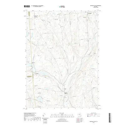
2019 Map of Smithville Flats
USGS Topo · Published 2019About this map
Smithville Flats serves as a primary focal point in this landscape where the Genegantslet Creek valley meets a network of upland ridges. The geography is defined by a series of north-south running streams and numerous upland water bodies, including Cincinnatus Lake, Long Pond, and Round Pond. Historically significant sites for genealogists include several well-distributed burial grounds such as Maple Grove Cem, Ashcraft Cem, and the Knickerbocker Cem near the southern boundary. The map illustrates a rural settlement pattern characterized by small hamlets like Lakeville and German Four Corners, connected by a grid of local roads that navigate the varying elevations of peaks like Bolster Hill and Meeker Hill. Numerous named wetlands, such as Hopkins Swamp and Brown Swamp, suggest a terrain that remains largely undeveloped and rich in natural drainage features.
Find a feature on this map
98 named features on this map. Tap any name to fly to it.
Don’t see what you’re looking for? This feature index may not catch every label — zoom into the map to look around manually.
Map Details
Editions of this 2019 Smithville Flats Map
This is the sole edition of this map. No revisions or reprints were ever made.
Other maps of this area

1902 · Coventry
USGS Topo · 1:62,500

1903 · Norwich
USGS Topo · 1:62,500

1904 · Greene
USGS Topo · 1:62,500

1904 · Oxford
USGS Topo · 1:62,500

1904 · Pitcher
USGS Topo · 1:62,500

1943 · Cincinnatus
USGS Topo · 1:24,000

1943 · East Pharsalia
USGS Topo · 1:24,000

1943 · Pitcher
USGS Topo · 1:24,000
1943 · Norwich
USGS Topo · 1:62,500
1944 · Pitcher
USGS Topo · 1:31,680