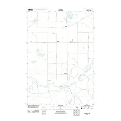
2011 Map of Smithville
USGS Topo · Published 2011About this map
The Manistee River winds through the southern portion of this region, serving as a primary geographical anchor near the community of Smithville. The landscape is defined by a high density of small water bodies and glacial features, including Twentyeight Lakes in the north and several named basins like Sickle Lake and Ingersoll Lake to the west. Small settlements such as Deibert, Giddings, and Millers Corners are connected by a regular grid of section roads, indicating the area's agricultural and rural residential layout. For those researching local history, the map identifies specific landmarks like the Garfield Lookout Tower and provides the exact locations of Deibert Cemetery and Garfield Cemetery. The transition from the flatlands around Taffeltown to the rise of Twentyone Hill illustrates the varied elevations found in this part of Michigan.
Find a feature on this map
67 named features on this map. Tap any name to fly to it.
Don’t see what you’re looking for? This feature index may not catch every label — zoom into the map to look around manually.
Map Details
Editions of this 2011 Smithville Map
This is the sole edition of this map. No revisions or reprints were ever made.
Other maps of this area

1954 · Traverse City
USGS Topo · 1:250,000

1956 · Kalkaska
USGS Topo · 1:62,500

1956 · Fife Lake
USGS Topo · 1:62,500

1956 · Cadillac North
USGS Topo · 1:62,500

1956 · Lake City
USGS Topo · 1:62,500

1958 · Traverse City
USGS Topo · 1:250,000

1983 · Cadillac
USGS Topo · 1:100,000

1983 · Stittsville
USGS Topo · 1:24,000

1983 · Traverse City
USGS Topo · 1:100,000
1983 · Morey
USGS Topo · 1:25,000