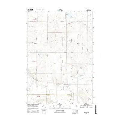
2014 Map of Smithville
USGS Topo · Published 2014About this map
The Manistee River winds through the southern portion of this landscape, marking a significant hydrological boundary just north of the Kalkaska Co Missaukee Co line. This 2014 survey documents a network of small settlements and rural crossroads that define the region's human geography, including Smithville, Taffeltown, and Millers Corners. The terrain is characterized by numerous glacial kettle lakes such as Ingersoll Lake, Jones Lake, and Twentyeight Lakes, which are interspersed with local landmarks like Twentyone Hill. For those tracing local heritage, the map identifies specific points of interest including Deibert Cem and Garfield Cem, alongside several named areas like Giddings and McGee that reflect the township's established settlement patterns. The extensive road network, featuring routes like Puffer RD SW and Ingersoll RD SW, connects these isolated points across the forested and undulating topography.
Find a feature on this map
88 named features on this map. Tap any name to fly to it.
Don’t see what you’re looking for? This feature index may not catch every label — zoom into the map to look around manually.
Map Details
Editions of this 2014 Smithville Map
This is the sole edition of this map. No revisions or reprints were ever made.
Other maps of this area

1954 · Traverse City
USGS Topo · 1:250,000

1956 · Kalkaska
USGS Topo · 1:62,500

1956 · Fife Lake
USGS Topo · 1:62,500

1956 · Cadillac North
USGS Topo · 1:62,500

1956 · Lake City
USGS Topo · 1:62,500

1958 · Traverse City
USGS Topo · 1:250,000

1983 · Cadillac
USGS Topo · 1:100,000

1983 · Stittsville
USGS Topo · 1:24,000

1983 · Traverse City
USGS Topo · 1:100,000
1983 · Morey
USGS Topo · 1:25,000