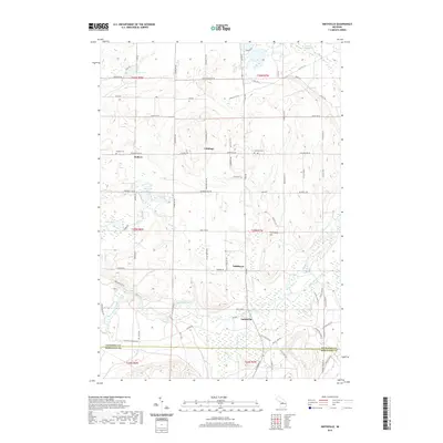
2019 Map of Smithville
USGS Topo · Published 2019About this map
The Manistee River winds through the southern portion of this landscape, serving as a primary geographic anchor for small settlements like Smithville and Taffeltown. The terrain is defined by a complex network of glacial features, including the prominent Twentyone Hill and a high density of wetlands and lakes such as East Lake Swamp, Woodard Lake, and Sickle Lake. Small rural clusters and family-named locations appear across the townships, including Giddings and Deibert, the latter of which is associated with the nearby Deibert Cem. These small centers are connected by a grid of local roads like Luce Rd and Sharon Rd SW. The map also captures the boundary between Kalkaska Co and Missaukee Co in the south, illustrating how these local communities were situated relative to the river systems and tributary creeks like Little Cannon Creek and Waterhole Cr.
Find a feature on this map
87 named features on this map. Tap any name to fly to it.
Don’t see what you’re looking for? This feature index may not catch every label — zoom into the map to look around manually.
Map Details
Editions of this 2019 Smithville Map
This is the sole edition of this map. No revisions or reprints were ever made.
Other maps of this area

1954 · Traverse City
USGS Topo · 1:250,000

1956 · Kalkaska
USGS Topo · 1:62,500

1956 · Fife Lake
USGS Topo · 1:62,500

1956 · Cadillac North
USGS Topo · 1:62,500

1956 · Lake City
USGS Topo · 1:62,500

1958 · Traverse City
USGS Topo · 1:250,000

1983 · Cadillac
USGS Topo · 1:100,000

1983 · Stittsville
USGS Topo · 1:24,000

1983 · Traverse City
USGS Topo · 1:100,000
1983 · Morey
USGS Topo · 1:25,000