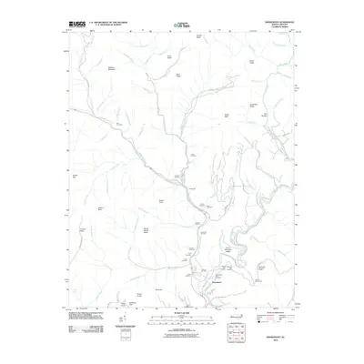
2010 Map of Smokemont
USGS Topo · Published 2010About this map
Smokemont and Ravensford sit at the center of this mountain landscape where the Oconaluftee River meets Bradley Fork and Raven Fork. This terrain is defined by a high density of family and community burial grounds, including the Slave Cemetery, Bradley Cemetery, and Husky Cemetery, offering significant genealogical data for those researching the region's early residents. The geography is characterized by prominent heights like Mount Noble and Richland Mountain, alongside specific topographical landmarks such as The Gorges and Tuskee Gap. Infrastructure is marked by the winding route of the Blue Ridge Pkwy, which navigates the ridges through the Rattlesnake Mountain Tunnel and Sherrill Cove Tunnel. The map also identifies numerous overlooks, such as the Ballhoot Scar Overlook, providing specific points of interest within the protected parklands.
Find a feature on this map
88 named features on this map. Tap any name to fly to it.
Don’t see what you’re looking for? This feature index may not catch every label — zoom into the map to look around manually.
Map Details
Editions of this 2010 Smokemont Map
This is the sole edition of this map. No revisions or reprints were ever made.
Other maps of this area

1891 · Cowee
USGS Topo · 1:125,000

1893 · Mt Guyot
USGS Topo · 1:125,000

1897 · Cowee
USGS Topo · 1:125,000

1907 · Cowee
USGS Topo · 1:125,000

1912 · Mt Guyot
USGS Topo · 1:125,000

1933 · Bryson
USGS Topo · 1:62,500

1935 · Addie
USGS Topo · 1:24,000

1936 · Bunches Bald
USGS Topo · 1:24,000
1936 · Whittier
USGS Topo · 1:24,000
1936 · Bryson
USGS Topo · 1:24,000
Featured Places
- Birdtown Community, NC
- Yellowhill Community, NC
- Big Cove Community, NC
- Tow String, NC
- Painttown Community, NC