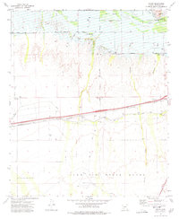
1973 Map of Smurr
USGS Topo · Published 1977About this map
The Gila River corridor south of the Gila Bend area defines this landscape during the early 1970s. The northern portion of the quadrangle is occupied by the Gila Bend Indian Reservation, where the waterway meets irrigation infrastructure like the Citrus Ditch and the Gila Bend Canal. The Southern Pacific railroad cuts a straight line through the center of the desert, passing through small sidings and map points such as Smurr, Ceda, and Tosa.
Find a feature on this map
26 named features on this map. Tap any name to fly to it.
Don’t see what you’re looking for? This feature index may not catch every label — zoom into the map to look around manually.
Map Details
Editions of this 1973 Smurr Map
This is the sole edition of this map. No revisions or reprints were ever made.
Other maps of this area

1950 · Theba
USGS Topo · 1:62,500

1951 · Gila Bend
USGS Topo · 1:62,500

1951 · Theba
USGS Topo · 1:62,500

1951 · Cotton Center
USGS Topo · 1:62,500

1951 · Woolsey Peak
USGS Topo · 1:62,500

1953 · Ajo
USGS Topo · 1:250,000

1954 · Phoenix
USGS Topo · 1:250,000

1957 · Ajo
USGS Topo · 1:250,000

1957 · Phoenix
USGS Topo · 1:250,000

1958 · Ajo
USGS Topo · 1:250,000