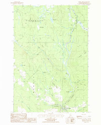
1986 Map of Smyrna Mills
USGS Topo · Published 1986About this map
The East Branch Mattawamkeag River flows through this corner of Aroostook County, defining a landscape marked by small settlements and numerous inland water bodies. In the mid-1980s, Smyrna Mills serves as the primary hub at the southern edge of the sheet, situated near the confluence of Dyer Brook and the main river. Northward, the terrain transitions into the forested uplands of Merrill and Dudley townships, where family-named landmarks like Charley Anderson Pond and the small hamlet of Shorey suggest a history of rural persistence. The mapping of Huntley Mill Pond and various ridge lines, such as Emerson Ridge and Dudley Brook Ridge, illustrates the topographic character that once supported local timber and milling operations. Genealogists may find interest in the documented Cem and isolated settlements like Dudley, which reflect the early surveying divisions of the Maine woods.
Find a feature on this map
34 named features on this map. Tap any name to fly to it.
Don’t see what you’re looking for? This feature index may not catch every label — zoom into the map to look around manually.
Map Details
Editions of this 1986 Smyrna Mills Map
This is the sole edition of this map. No revisions or reprints were ever made.
Other maps of this area

1935 · Howe Brook
USGS Topo · 1:48,000

1937 · Smyrna Mills
USGS Topo · 1:62,500

1939 · Howe Brook
USGS Topo · 1:62,500

1940 · Island Falls
USGS Topo · 1:62,500

1940 · Oxbow
USGS Topo · 1:62,500

1942 · Island Falls
USGS Topo · 1:62,500

1942 · Oxbow
USGS Topo · 1:62,500

1954 · Howe Brook
USGS Topo · 1:62,500

1954 · Presque Isle
USGS Topo · 1:250,000

1955 · Smyrna Mills
USGS Topo · 1:62,500