
1940 Map of Smyrna
USGS Topo · Published 1961About this map
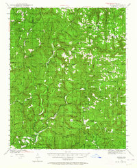
Illinois Bayou and its numerous forks and hollows define this section of the Arkansas Ozarks as it appeared just before the mid-century. The landscape is characterized by small, isolated communities like Smyrna, Lost Corner, and Solo, many of which were centered around local education and faith at sites like Union Hill Sch, Atkins Sch, and New Hope Sch. This period shows a network of early roads and a solitary Motorway traversing the high ridges, connecting family-named landmarks such as Shields Knob and Alread Hill.
Find a feature on this map
84 named features on this map. Tap any name to fly to it.
Don’t see what you’re looking for? This feature index may not catch every label — zoom into the map to look around manually.
Map Details
Editions of this 1940 Smyrna Map
2 editions found
Other maps of this area

1879 · Washington
USGS Topo · 1:62,500

1887 · Smyrna
USGS Topo · 1:62,500

1888 · Dardanelle #1
USGS Topo · 1:62,500

1889 · Treat
USGS Topo · 1:62,500

1889 · Marshall #3
USGS Topo · 1:62,500

1890 · Dardanelle
USGS Topo · 1:125,000

1892 · Marshall
USGS Topo · 1:125,000

1892 · Morrillton
USGS Topo · 1:125,000

1894 · Morrillton
USGS Topo · 1:125,000

1894 · Marshall
USGS Topo · 1:125,000