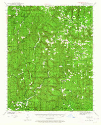
1940 Map of Smyrna
USGS Topo · Published 1964About this map
Illinois Bayou and its numerous forks dominate this rural landscape in the Arkansas Ozarks, surveyed just before the 1940s. The settlement pattern is defined by high-elevation ridges and deep hollows like Bear Hollow and Wolf Den Hollow, where small communities such as Smyrna and Nogo served as local hubs. This era shows a high density of rural schoolhouses, including Union Hill Sch, Zion Hill Sch, and Atkins Sch, which often served as the primary social centers for remote townships. Genealogists can identify family sites through named landmarks like Brogden Hollow and Millsaps Hollow, or via the Old Smyrna Cem and Hughes Cem. The presence of a fire tower on Raspberry Mtn highlights the early forest management efforts in the region, while the network of unpaved roads and the Motorway suggest a transition toward motorized access in these difficult-to-reach areas of Pope County and Van Buren County.
Find a feature on this map
82 named features on this map. Tap any name to fly to it.
Don’t see what you’re looking for? This feature index may not catch every label — zoom into the map to look around manually.
Map Details
Editions of this 1940 Smyrna Map
2 editions found

Other maps of this area

1879 · Washington
USGS Topo · 1:62,500

1887 · Smyrna
USGS Topo · 1:62,500

1888 · Dardanelle #1
USGS Topo · 1:62,500

1889 · Treat
USGS Topo · 1:62,500

1889 · Marshall #3
USGS Topo · 1:62,500

1890 · Dardanelle
USGS Topo · 1:125,000

1892 · Marshall
USGS Topo · 1:125,000

1892 · Morrillton
USGS Topo · 1:125,000

1894 · Morrillton
USGS Topo · 1:125,000

1894 · Marshall
USGS Topo · 1:125,000