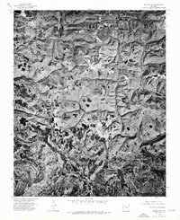
1974 Map of Smyrna SE
USGS Topo · Published 1975About this map
The settlement of Lost Corner is the central human landmark in this 1974 orthophotoquad, which captures the heavily wooded and dissected plateau of the Ozarks in Van Buren County. Unlike traditional topographic maps, this aerial imagery reveals the actual density of the forest canopy and the precise clearings maintained for agriculture and homesteads during the mid-1970s. The drainage of Illinois Bayou or its tributaries carves through the terrain, illustrating the remote and isolated character of north-central Arkansas. Genealogists and local historians can use this specific visual record to identify exact structure locations and land use patterns that traditional line-and-symbol maps might generalize, providing a rare photographic baseline for this rural upland area.
Find a feature on this map
2 named features on this map. Tap any name to fly to it.
Don’t see what you’re looking for? This feature index may not catch every label — zoom into the map to look around manually.
Map Details
Editions of this 1974 Smyrna SE Map
This is the sole edition of this map. No revisions or reprints were ever made.
Other maps of this area

1879 · Washington
USGS Topo · 1:62,500

1887 · Smyrna
USGS Topo · 1:62,500

1889 · Marshall #3
USGS Topo · 1:62,500

1892 · Marshall
USGS Topo · 1:125,000

1892 · Morrillton
USGS Topo · 1:125,000

1894 · Morrillton
USGS Topo · 1:125,000

1894 · Marshall
USGS Topo · 1:125,000

1901 · Marshall
USGS Topo · 1:125,000

1940 · Smyrna
USGS Topo · 1:62,500
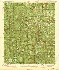
1943 · Smyrna
USGS Topo · 1:62,500