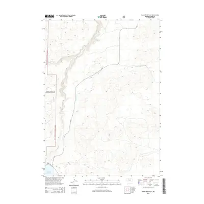
2014 Map of Snake River Falls
USGS Topo · Published 2014About this map
Snake River Falls defines this stretch of the Nebraska Sandhills, where water engineering and conservation land meet. This 2014 survey documents the complex hydrological network of the Snake River, notably where the Ainsworth Canal diverts from the main channel to support regional agriculture. The southern boundary is anchored by the northern reaches of the Merritt Reservoir, a vital irrigation and recreation pool accessed via Merritt-Dam Rd. Along the western edge, the map covers the eastern boundary of the Sam R. McKelvie National Forest, illustrating a landscape of transition between protected forest land and the open, undulating terrain surrounding Steer Cr. The presence of Ne-97 provides the primary north-south transit corridor through this sparsely populated section of Cherry County.
Find a feature on this map
8 named features on this map. Tap any name to fly to it.
Don’t see what you’re looking for? This feature index may not catch every label — zoom into the map to look around manually.
Map Details
Editions of this 2014 Snake River Falls Map
This is the sole edition of this map. No revisions or reprints were ever made.
Other maps of this area

1950 · Simeon
USGS Topo · 1:62,500

1950 · Kennedy
USGS Topo · 1:62,500

1950 · Kilgore
USGS Topo · 1:62,500

1950 · Valentine
USGS Topo · 1:62,500

1957 · Valentine
USGS Topo · 1:250,000

1959 · Valentine
USGS Topo · 1:250,000

1983 · Valentine SW
USGS Topo · 1:24,000
1985 · Kilgore SE
USGS Topo · 1:24,000

1985 · Cooper Canyon
USGS Topo · 1:24,000
1985 · Windmill Lake
USGS Topo · 1:24,000