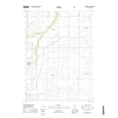
2017 Map of Snake River Falls
USGS Topo · Published 2017About this map
The Samuel R McKelvie National Forest occupies the western portion of this Cherry County landscape, where the Snake River carves a winding path through the Sandhills. A notable geographic feature is the Snake River Falls, located where the river bends sharply northward before feeding into the northern reaches of the Merritt Reservoir. This 2017 survey captures the essential water management infrastructure of the region, including the Ainsworth Canal which diverts water from the reservoir to support agricultural needs further east. The terrain is characterized by complex dune formations and small intermittent basins, with Steer Cr joining the river system from the northwest. Primitive transportation routes like Pr Dr and the paved Merritt Dam Rd provide the few points of access into this protected forest and waterway corridor.
Find a feature on this map
12 named features on this map. Tap any name to fly to it.
Don’t see what you’re looking for? This feature index may not catch every label — zoom into the map to look around manually.
Map Details
Editions of this 2017 Snake River Falls Map
This is the sole edition of this map. No revisions or reprints were ever made.
Other maps of this area

1950 · Simeon
USGS Topo · 1:62,500

1950 · Kennedy
USGS Topo · 1:62,500

1950 · Kilgore
USGS Topo · 1:62,500

1950 · Valentine
USGS Topo · 1:62,500

1957 · Valentine
USGS Topo · 1:250,000

1959 · Valentine
USGS Topo · 1:250,000

1983 · Valentine SW
USGS Topo · 1:24,000
1985 · Kilgore SE
USGS Topo · 1:24,000

1985 · Cooper Canyon
USGS Topo · 1:24,000
1985 · Windmill Lake
USGS Topo · 1:24,000